MAIN MENU
CATALOG INDEX
BY ALPHABETICAL
ORDER
For more info:
mailto:JSi@jsits.com
[ CMT Alto-G12
]
[ CMT CogoCad ]
[ CMT Contour and
Volume for
Windows ]
[ CMT GPS Base Station
]
[ CMT
HP-GPS-L4 ]
[ CMT March ]
[
CMT MC GPS ]
[
CMT PC5L-GPS ]
[
CMT PC-GPS 3.2
for
Windows ]
[ CMT GPS-REC-CR,
12-channel
High
Precision Base
Station ]
[ CMT Winbase ]
[
CMT Z33
Dual-frequency
GPS ]
[ GARMIN GBR 21 ]
[
GARMIN GPS II
]
[ GARMIN GPS II
Plus ]
[ GARMIN GPS III
]
[ GARMIN GPS
12 ]
[ GARMIN GPS
48 ]
[ GARMIN GPSCom 170
]
[ GARMIN GPSmap
130 ]
[ GARMIN
GPSMAP 175 ]
[ GARMIN GPSMAP
210
& 220 ]
[ GARMIN
GPSmap
235 Sounder ]
| PC-GPS 3.2 combines CTM's proven GPS project management utilities with powerful mapping functions in one package. It can be used as part of a complete system with a CTM GPS data collector or as a stand-alone resource mapping program. PC-GPS 3.2 is also compatible with ARC/INFO®, ArcView® and AutoCAD®. | 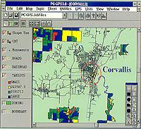 |
Best of all, you don't need to be a GIS expert to use PC-GPS 3.2. Many of the functions available in more complicated GIS or mapping programs are readily accessible. When you need advanced capabilities, PC-GPS 3.2 provides power beyond standard mapping programs with the support of Microsoft's® Open DataBase Connectivity (ODBC), Object Linking & Embedding (OLE), and Advanced Programming Interface (API).
Specifications and
Functions
PC-GPS 3.2 is a versatile GPS
Mapping program which can be used as part of a complete GPS system or as a
stand-alone resource mapping program. A brief listing of the
specifications and functions of the program follows.
Operating Specifications
- IBM PC or compatible with 486 processor or better
- Microsoft Windows 3.1® or Windows 95®
- 8 MB RAM minimum; 16 MB or more is reccomended
GPS Hardware Compatibility
- MARCH
- MC5-GPS
- PC5L-GPS
- HP-GPS-L4
- Leica MX8600
GPS Processing
- Complete GPS job management and processing
- Mission Planning
- Differential Correction/Coordinate Analysis
- Hierarchical Feature List
- WayPoint and Route management
Map Building
- Map building using many different data sources
- GPS Feature Files
- DXF Files
- ASCII Files
- ESRI® Shapefiles
- WayPoint and Route Files
- Digital Images - BITMAP and TIFF formats
- Support of UTM, SPC, LLA and user-defined coordinate system
Resource Analysis
- Data search and filter
- Feature classification
- Area/length determination
Database Support
- Export GPS and Map data to Microsoft® ODBC compliant databases
- Microsoft Access®, dBASE®, Foxpro® and others
- Import and filter PC-GPS data from databases
Object Linking
- Embed and link Microsoft® OLE compliant objects
- Video, audio, graphics, digital photos, documents & spreadsheets
GIS Output
- ARC/INFO®
- AutoCAD® DXF
- ESRI® Shape file
Powerful Mapping Functions
Your
Map can be created using a variety of data sources: GPS Feature files, DXF
files, ASCII Files, ESRI® Shapefiles (.SHP), databases, and digital
images. The geographic and image data in your Map is automatically
organized into layers to facilitate map viewing and data management. Your
completed Map can be displayed in UTM, SPC, LLA or even a user-defined
Coordinate System.
Once your Map is created, it can be plotted complete with custom legends, labels and objects. Each Feature in the Map can be labeled by Feature name or by specific value. Tailor the size, style or color of labels shapes and text to suit your needs.
GPS Processing
If you have a GPS data collector, PC-GPS 3.2 can help you manage your GPS data collection "jobs" from start to finish. Prior to field data collection, you may identify optimal times for GPS reception using Mission Planning. In addition, you may want to Construct "Feature List" of Features, Attributes, and Values to promote organized and convenient field data collection. Following GPS collection, use our advanced differential correction to improve the accuracy of your GPS data. Finally, export your data to your GIS system or create a complete map within PC-GPS 3.2.
Impressive Visual Tools: Image &
Objects
PC-GPS 3.2 enhances your data with digital
images (.BMP, .TIF) and even multimedia objects conforming to Microsoft's®
OLE standard. Images, such as aerial photos, can be georeferenced to your
Map within PC-GPS. Create new features from your image using "heads-up
digitizing". Vividly describe features by linking descriptive objects like
video/audio clips, documents and spreadsheets to a specific Point, Line or
Area.
Resource and Data
Management
PC-GPS 3.2 offers a number of powerful data
analysis and management functions. Analyze the Feature, Attribute and
Value data in your Map using powerful Filter, Search and Classification
tools. With classification, you can create data subgroups or color-coded
classes. Calculate Feature areas and lengths or measure map distances at
the click of a button. View your attribute and value data in spreadsheet
form for quick reference and editing.
Export Feature Data from PC-GPS 3.2 to your
Database Program
If you need to perform more extensive
analysis or reporting functions, export your map data directly to a number
of databases such as Access®, dBASE®, Foxpro® and other Microsoft® ODBC
compliant programs. PC-GPS data can then be joined with your existing GIS
database. Finally, you can import all your data, or only a portion of
data, back into PC-GPS 3.2.