MAIN MENU
CATALOG INDEX
BY ALPHABETICAL
ORDER
For more info:
mailto:JSi@jsits.com
[ CMT Alto-G12
]
[ CMT CogoCad ]
[ CMT Contour and
Volume for
Windows ]
[ CMT GPS Base Station
]
[ CMT
HP-GPS-L4 ]
[ CMT March ]
[
CMT MC GPS ]
[
CMT PC5L-GPS ]
[
CMT PC-GPS 3.2
for
Windows ]
[ CMT GPS-REC-CR,
12-channel
High
Precision Base
Station ]
[ CMT Winbase ]
[
CMT Z33
Dual-frequency
GPS ]
[ GARMIN GBR 21 ]
[
GARMIN GPS II
]
[ GARMIN GPS II
Plus ]
[ GARMIN GPS III
]
[ GARMIN GPS
12 ]
[ GARMIN GPS
48 ]
[ GARMIN GPSCom 170
]
[ GARMIN GPSmap
130 ]
[ GARMIN
GPSMAP 175 ]
[ GARMIN GPSMAP
210
& 220 ]
[ GARMIN
GPSmap
235 Sounder ]
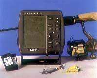 Compact, Full
Featured Chartplotting with Digital Cartography
Compact, Full
Featured Chartplotting with Digital Cartography
The
GPSMAP 130™ gives you an incredible array of features in a compact package
that will fit almost any boat, and any budget.
User-friendly
operating software makes the GPSMAP130 a pure pleasure to use. And the
long list of features that include advanced fuel and trip planning,
built-in planning, built-in simulator, nearest and proximity waypoints,
along with clock, arrival, crosstrack, anchor and timer alarms will soon
make you wonder how you ever got along without it.
The large, crisp
4.1 inch diagonal, backlit, LCD display provides the clearest navigation
picture available on a marine GPS of this size. Plug-in G-chart™ offshore
and inland cartography puts the map of your choice at your fingertips.
- PhaseTrac12™ receiver continuously tracks and uses up to 12 satellites simultaneously for fast, accurate positioning.
- Large, electroluminescent backlit, gray-scale (3-level) high resolution LCD display with crisp graphics and moving map plotting with full-featured zooming and panning capability.
- 3-D graphic highway steering guidance with user view range.
- GARMIN G-chart™ inland water and offshore cartography and built-in worldwide Navionics© database provide seamless coverage anywhere you go.
- Innovative Tracback™ feature lets you quickly navigate a track log back to port without manually entering waypoints.
| Navigation features | ||
| Waypoints: | Total: | 250 alphanumeric |
| Nearest: | 9 (automatic) | |
| Proximity: | 9 (definable) | |
| Routes: | 20 reversible with up to 30 points each, plus MOB mode | |
| Map datums: | Over 100 | |
| Performance | ||
| Receiver: | Differential-ready PhaseTrac12™ continuously tracks and uses up to twelve satellites to compute and position | |
| Acquisition Times: | Warm: | Approx. 15 seconds |
| Cold: | Approx. 45 seconds | |
| AutoLocate™: | Approx. 5 minutes | |
| Update Rate: | 1/second, continuous | |
| Accuracy: | Position: | 15 meters (49) RMS* 5-10 meters (16-33feet) RMS with GARMIN GBR 21 DGPS receiver (optional) |
| Velocity**: | 0.1 knot RMS steady state | |
| Dynamics: | 6g3 | |
| Interfaces: | NMEA 0180, 0812, 0813 and RTCM 104 DGPS corrections | |
| Antenna: | GA 28 Remote Marine Mount with 30' cable | |
| Plotter/Moving Map Features | ||
| Database: | Built-in worldwide to 64 nm | |
| Data Cartridges: | G-chart cartridges with inland water and Navionics offshore cartography for seamless, detailed mapping and world wide coverage (optional) | |
| Plotting Scales: | 1/8 to 4096 nm with dedicated push-button zoom control | |
| Physical | ||
| Size: | 4.9" H x 5.3" W x 2.4" D (12.5 x 13.46 x 6.1 cm) | |
| Weight: | Less than 1.1 lb. (495 g) | |
| Display: | 4.1" diagonal (10.4 cm) high-contrast, LCD with backlighting (160 x 240 pixels) | |
| Case: | Waterproof tested, dry nitrogen-filled | |
| Temp. Range: | 5°F to 158°F (-15°C to 70°C) | |
| Power | ||
| Source: | 10-40v DC | |
| Usage: | 3 watts max. | |
| Accessories | ||
| Standard: |
| |
| Optional: |
| |
Specifications are preliminary and subject to change without
notice.
* Subject to accuracy degradation to 100m 3DRMS under the
United States of Defense-imposed Selection Availability
Program.