MAIN MENU
CATALOG INDEX
BY ALPHABETICAL
ORDER
For more info:
mailto:JSi@jsits.com
[ CMT Alto-G12
]
[ CMT CogoCad ]
[ CMT Contour and
Volume for
Windows ]
[ CMT GPS Base Station
]
[ CMT
HP-GPS-L4 ]
[ CMT March ]
[
CMT MC GPS ]
[
CMT PC5L-GPS ]
[
CMT PC-GPS 3.2
for
Windows ]
[ CMT GPS-REC-CR,
12-channel
High
Precision Base
Station ]
[ CMT Winbase ]
[
CMT Z33
Dual-frequency
GPS ]
[ GARMIN GBR 21 ]
[
GARMIN GPS II
]
[ GARMIN GPS II
Plus ]
[ GARMIN GPS III
]
[ GARMIN GPS
12 ]
[ GARMIN
GPSCom 170 ]
[ GARMIN GPSMAP 175
]
[ GARMIN
GPSMAP
210
& 220 ]
CMT Alto-G12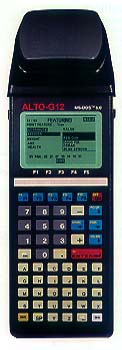
- The only sub-meter integrated hand-held GPS/GIS receiver on the market.
- Very good for precision farming, hydrographic surveys, etc.
- Signal inaccuracies are removed with RAIM (Receiver Autonomous Integrity Monitor). Built-in strobe correlator technology provides unmatched multi-path mitigation for code.
Specifications
| Accuracy | |
| Real-time Diffrential (DGPS) | |
| DGPS (CEP) | 40 cm |
| DGPS (2DRMS) | 90 cm |
| DGPS (typical) | 60 - 100 cm |
| Post-processing | |
| L1 Carrier phase post-processing | |
| Static (RMS) | 2 cm + 2 ppm |
| Static (2DRMS) | 90 cm |
| L1 C/A code post-processing | |
| Static (CEP) | 40 cm |
| Static (2DRMS) | 90 cm |
| Static (typical) | 50-90 cm |
| Time to first fix | 45 sec
typical 20 sec with current ephemeris |
| Reacquisition | 2 sec |
| Velocity (RMS) | .05 m/s |
| Maximum velocity | 460 m/sec |
| Maximum altitude | 18 000 m |
| Sustained acceleration | 20 G |
Features
- 12 channel L1 frequency
- Strobe Correlator technology
- Full wavelength carrier phase on L1
- Carrier-phase smoothing
- RTCM-104 Ver. 2.2 input
- NMEA 0.183 Ver. 2.2 output
- 1 PPs timing signal
Alto-G12 Physical
- Waterproof (submersible)
- Operating temperature: -40°C to 54°C
- 16 line x 25 character backlit display
- 4MB RAM standard (8MB optional)
- Fully integrated GPS receiver, antenna and data collector in one hand-held unit
- 55-key alphanumeric keyboard including 5 function keys and separate numeric keypad
- Optional external antenna
- Field-replaceable rechargeable battery
- Up to 8 hrs. operation on rechargeable battery
Alto-G12 Capabilities
- Graphic plotting
- Traversing keyboard data entry to allow you to continue mapping when GPS in obstructed
- Offset function to map hard-to-reach locations
- Nested point function for tagging points while you are mapping a line or area feature
- Averaging function to optimize accuracy while recording static points
- LLA/UTM/SPC plus user-defined datums
- Provides area calculation in the field
- Interfaces to laser rangefingers, barcode readers and various NMEA devices
- Two 9-pin RS-232 serial ports, PC/AT pinout
The Alto-G12 package included CMT's PC-GPS 3.6 software for comprehensive GPS project management and mapping. PC-GPS 3.6 provides functions for Mapping, Mission Planning, Batch Differential Correction, Static Point "Spread" analysis and Job Editing. The software also supports GIS layering, raster images (i.e. DOQs, DRGs, aerial photographs, satellite imagery), multimedia objects (OLE 2.0) and Microsoft® ODBC.