MAIN MENU
CATALOG INDEX
BY ALPHABETICAL
ORDER
For more info:
mailto:JSi@jsits.com
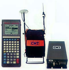
[ CMT Alto-G12
]
[ CMT CogoCad ]
[ CMT Contour and
Volume for
Windows ]
[ CMT GPS Base Station
]
[ CMT
HP-GPS-L4 ]
[ CMT March ]
[
CMT MC GPS ]
[
CMT PC5L-GPS ]
[
CMT PC-GPS 3.2
for
Windows ]
[ CMT GPS-REC-CR,
12-channel
High
Precision Base
Station ]
[ CMT Winbase ]
[
CMT Z33
Dual-frequency
GPS ]
[ GARMIN GBR 21 ]
[
GARMIN GPS II
]
[ GARMIN GPS II
Plus ]
[ GARMIN GPS III
]
[ GARMIN GPS
12 ]
[ GARMIN
GPSCom 170 ]
[ GARMIN GPSMAP 175
]
[ GARMIN
GPSMAP
210
& 220 ]
 Includes
- RTK, OTF, Static
- Stakeout
- Geoid Model in field
- Base Station Software
- Office PC-GPS Software
- Dual-F GPS Base unit
- Dual-f GPS Rover unit
- PC5L Hand-held with 8 Megabyte RAM
- Base Station RTK Radio
- Rover RTK radio
- Rover Backpack
CMT Field 4.0
- Power survey functionality
- Stakeout (Point, Line, Arc, Slope)
- Traverse, COGO, Offset
- Coordinate system
- User-defined coordinates
- Locate plane (NEZ)
- SPC, UTM, LLA
- GPS Survey/GIS data collection
- Points, Lines, Areas
- Features/Attributes/Values
- 12-channel L1
- C/A code, P code and full-wavelength carrier tracking
- 12-channel L2
- P code and full wavelength carrier tracking
- Quick Initialization with OTF
- This standard function allows the system to initialize while the GPS unit is moving.
- GEOID model in rover unit for in-field accurate MSL (Mean Sea Level) height
- RTK - Real-Time kinematic Position accuracy: 2 cm + 1 ppm
- Static - Carrier Phase Differential Position accuracy: 5 mm + 1 ppm
Accuracy
| RTK | |
| Static Horizontal (RMS) | 1 cm + 1 ppm |
| Static Vertical (RMS) | 1.7 cm + 1 ppm |
| Min. Static occupation time | 2
seconds Sub-centimeter accuracy with longer occupation time |
| Kinematic Horizontal (RMS) | 3 cm + 1 ppm |
| Kinematic Vertical (RMS) | 5 cm + 1 ppm |
| Azimuth (arc sec) | .15 _ 1.5/baseline length in km |
| Initialization time to fix ambiguities | Low as 10 sec after P-code lock on 8 satellites |
| Real-time Differential (DGPS) | |
| DGPS (RMS) | < 1 m + 10 ppm |
| Post-processing | |
| L1/L2 Carrier phase post-processing | |
| Static (RMS) | 5 mm + 1 ppm |
| Kinematic (RMS) | 1 cm + 1 ppm |
| L1 C/A code post-processing | |
| DGPS (RMS) | <1 m + 10 ppm |
Features
- 12 channel L1 / 12 channel L2
- Full wavelength carrier phase on L1 and L2
- P-code on L1 and L2
- Z-Tracking
- L1 C/A code
- On-the-fly (OTF) initialization
- Real-time kinematic for cm-accuracy
- Operational under Anti-spoofing (AS) conditions
- Up to 13 db signal-to-noise advantage over cross correlation for tracking weaker satellite signals
- Fast signal acquisition and reacquisition algorithms
- Low data latency
- Up to 10 Hz position and raw data rate
- Real-time data output
- RTCM-SC104 V.2.1 for DGPS and RTK
- Rinex Ver. 2.0
- NMEA 0183 V. 2.01
- 1 PPs timing signal
- Event marker
Physical
- Operating temperature: -40°C ro 65°C
- Power consumption: 7.5 Watts
- Input voltage: 10-28 VDC
- Humidity: 100% condensing
Data Collector
- Waterproof (submersible)
- Operating temperature: -40°C to 54°C
- 8 MB RAM standard, 1 MB Flash EPROM
- 2D/3D point, offset, slope staking
- COGO traverse, inverse, intersect, horz, curve, create line, create arc, 3-point curve
- NEZ calibration for working on local planes
- LLA/UTM/SPC plus user-defined coordinates
- Supports datums plus user-defined datums
- Geoid model on-board for accurate MSL in the field
The CMT Z33 package includes CMT's PC-GPS 4.0 software for comprehensive GPS project management and mapping. PC-GPS 4.0 provides functions for mapping, Mission Planning, Batch Differential Correction, Static Point "Spread" analysis and Job Editing. The software also supports GIS layering, raster images (i.e. DOQs, DRGs, aerial photographs, satellite imagery), multimedia objects (OLE 2.0), Microsoft® ODBC and extensive Coordinate Geometry (COGO) functions.