MAIN MENU
CATALOG INDEX
BY ALPHABETICAL
ORDER
For more info:
mailto:JSi@jsits.com
[ CMT Alto-G12
]
[ CMT CogoCad ]
[ CMT Contour and
Volume for
Windows ]
[ CMT GPS Base Station
]
[ CMT
HP-GPS-L4 ]
[ CMT March ]
[
CMT MC GPS ]
[
CMT PC5L-GPS ]
[
CMT PC-GPS 3.2
for
Windows ]
[ CMT GPS-REC-CR,
12-channel
High
Precision Base
Station ]
[ CMT Winbase ]
[
CMT Z33
Dual-frequency
GPS ]
[ GARMIN GBR 21 ]
[
GARMIN GPS II
]
[ GARMIN GPS II
Plus ]
[ GARMIN GPS III
]
[ GARMIN GPS
12 ]
[ GARMIN GPS
48 ]
[ GARMIN GPSCom 170
]
[ GARMIN GPSmap
130 ]
[ GARMIN
GPSMAP 175 ]
[ GARMIN GPSMAP
210
& 220 ]
[ GARMIN
GPSmap
235 Sounder ]
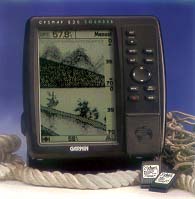 The GPSMAP
235 Sounder offers the advantage of an innovative depth sounder and the
proven performance of GARMIN GPS chartplotting in a single, easy-to-use
package.
The GPSMAP
235 Sounder offers the advantage of an innovative depth sounder and the
proven performance of GARMIN GPS chartplotting in a single, easy-to-use
package.
GARMIN's 235 depth sounder is packed with a combination
of features you won't find any other sounder. Dual frequency operation
gives you the clearest possible image in both deep and shallow
water.
Powerful noise rejection effectively removes the most
stubborn cross talk and interference. Over 25 square inches of active
viewing area gives you sizeable detail coverage. A variable zoom window
allows you to view increased detail at the touch of a button. You can even
mark underwater waypoints to capture the position and depth of objects
like reefs, dropoffs or hazards, to permanently store them for future use.
Combine these innovations with a wide range of additional advanced
features, and it's easy to see that the GPSMAP 235 Sounder is designed to
give you all the information you need.
If having the best depth
sounder on the market isn't enough, add navigational guidance that is
second to none.
The GPSMAP 235 Sounder features GARMIN's high performance 12 parallel channel GPS receiver for unmatched accuracy and G-chart™ digital cartography for chartplotting on inland or offshore waters.
- Crisp, 4-level grayscale display and GARMIN's exclusive See-Thru™ technology separates black fish returns from the light gray returns of thermoclines and structure.
- One-touch instant zoom rescales entire screen, while 2X and 4X oversampling provides greater detail of the bottom.
- Innovative split screen display GPS cartography and sounder data simultaneously.
- Graphic whiteline display with Depth Controlled Gain (DGG™) feature always presents a clear image of bottom hardness, structure, and thermoclines not found in other fishfinders.
- Excellent sounder dynamic range for viewing weak signals in the presence of strong signals.
| Navigation features | ||
| Waypoints: | Total: | 250 alphanumeric |
| Nearest: | 9 (automatic) | |
| Proximity: | 9 (definable) | |
| Routes: | 20 reversible routes with up to 30 points waypoints each, plus MOB and TracBack™ modes | |
| Track Log: | Approx. 2,000 points | |
| Map datums: | 106 | |
| Coordinates: | Lat.Ion, UTM/UPS, plus 7 grids, including Maidenhead | |
| Performance | ||
| GPS
Receiver: |
Differential-ready PhaseTrac12™, 12 parallel channel receiver tracks all satellites in view | |
| Depth Sounder: | Frequency: | 50 % 200 KHz |
| Transmit Power: | 500 W RMS (4000 W peak to peak) | |
| GPS Acquisition Times: | Warm: | Approx. 15 seconds |
| Cold: | Approx. 45 seconds | |
| AutoLocate™: | Approx. 5 minutes | |
| Update Rate: | 1/second, continuous | |
| Accuracy: | Position: | 15 meters (49 feet) RMS* 1-5 meters (3-15 feet) RMS with GARMIN GBR 21 DGPS receiver (optional) |
| Velocity: | 0.1 knot RMS steady state | |
| Dynamics: | 6g's | |
| Interfaces: | NMEA 0180, 0812, 0813 and RTCM 104 DGPS corrections | |
| Antenna: | GA 28 Remote Marine Mount with 30' cable | |
| Plotter/Moving Map Features | ||
| Database: | Built-in worldwide to 64 nm | |
| Data Cartridges: | G-chart cartridges with inland water and Navionics offshore cartography for seamless, detailed mapping and world wide coverage (optional) | |
| Plotting Scales: | 1/8 to 4096 nm with dedicated push-button zoom control | |
| Depth Sounder Features | ||
| Display options: | Auto Bottom Tracking, Auto Ranging, 4 Zoom Levels, Splait Screen Feature, and 3-Level Fish ID | |
| Alarms: | Fish and Shallow/Deep Water | |
| Physical | ||
| Size: | 7.5" H x 7.7" W x 2.6" D (19.1 x 19.6 x 6.6 cm) | |
| Weight: | 2 lbs. (.908 kg) | |
| Display: | 7.25" diagonal (18.4 cm) high-contrast, 4-gray LCD with backlighting (160 x 240 pixels) | |
| Case: | Fully gasketed, high-impact plastic alloy | |
| Temp. Range: | 5°F to 158°F (-15°C to 70°C) | |
| Power | ||
| Source: | 10-40v DC | |
| Usage: | 15 watts max. | |
| Accessories | ||
| Standard: |
| |
| Optional: |
| |
Specifications are preliminary and subject to change without
notice.
* Subject to accuracy degradation to 100m 2DRMS under the
United States of Defense-imposed Selection Availability
Program.
**
Also available without a transducer.